Search
Close this search box.
Search
Close this search box.

CHCNAV BB4 Mini Survey Drone – Photogrammetry and LiDAR

The BB4 mini quadrotor UAV is a groundbreaking development for surveying and mapping applications. It boasts a cutting-edge intelligent flight control system that enables multi-scene data acquisition using LiDAR and camera technology. This system ensures precision and versatility, making the UAV capable of efficiently capturing data in a wide range of scenarios. With extended endurance, the BB4 mini can remain in flight for extended periods, reducing downtime and enhancing its data collection capabilities. This UAV sets a new standard for efficient data capturing by combining intelligence with superior performance, making it a valuable tool for various industries.

The BB4 mini is a versatile and efficient UAV that combines intelligent flight control with advanced sensor technology to excel in surveying and mapping. Its long endurance, multi-scenario adaptability, and automation capabilities mark a significant advancement in data collection for various applications.

Additional product info

Detailed quote form

Request A Free Quote – BB4 Mini

"*" indicates required fields

Drone Options

Select Drone

Payload Options

Select Payload

RTK Options

Select RTK Option
Name*
Call In?
Receive text messages from us?

By submitting this form, you hereby agree to receive communications from Bench Mark

Product details

  • Centimeter Level Positioning with NTRIP Corrections
  • No GCPs Required
  • Hemisphere S631, CanNet, BrandtNet, Smart Net and CORS Network Compatible
  • DJI Ground Control Software
  • Photo Replication
  • Multi-Battery Missions
  • 50 Minute Flight Time
  • 3.0 kg (6.6 lb) Payload

Package includes

  • BB4 Mini Lift Drone
  • Optional Payloads
  • Spare Propellors
  • Smart Charging Cable and Block
  • Charger
  • Batteries
  • Hard Case
  • SD Card
  • Dual RTK Modules
  • Controller

Description

The BB4 Mini Photogrammetry and LiDAR Drone

The modern BB4 mini quadrotor UAV boasts an innovative intelligent flight control system that revolutionizes data acquisition for surveying and mapping applications. This advanced system seamlessly integrates LiDAR and camera technology, offering a multi-scene data collection capability. Its standout features include remarkable endurance and versatility, setting a new standard for efficient data capture while marrying intelligence with exceptional performance.

Advanced Intelligent Flight Control System: The BB4 mini is at the forefront of drone technology with its brand-new intelligent flight control system. This system is not just a technological leap forward, but it’s a game-changer for surveying and mapping applications. It utilizes cutting-edge algorithms and software to enhance flight stability, precision, and automation. This means the UAV can adapt to different scenarios and conditions, ensuring that data acquisition is precise and consistent.

Multi-Scene Data Acquisition: The integration of LiDAR and camera technology is a significant feature of the BB4 mini. LiDAR (Light Detection and Ranging) provides the ability to create highly detailed 3D maps of the environment, while the camera adds high-resolution visual data. Together, these technologies enable the UAV to capture data from various angles and perspectives, making it incredibly versatile for different surveying and mapping tasks. It’s not limited to a single type of data but can acquire comprehensive and detailed information, making it valuable for applications ranging from land surveys to infrastructure inspections.

Long Endurance: The BB4 mini’s exceptional endurance is made possible through an advanced manufacturing process, known as the IWF manufacturing process. This process ensures the UAV’s high strength and light weight, making it capable of extended flight times. Longer endurance is a significant advantage for surveying and mapping applications. It means the UAV can cover larger areas without needing frequent battery changes, reducing downtime and increasing operational efficiency.

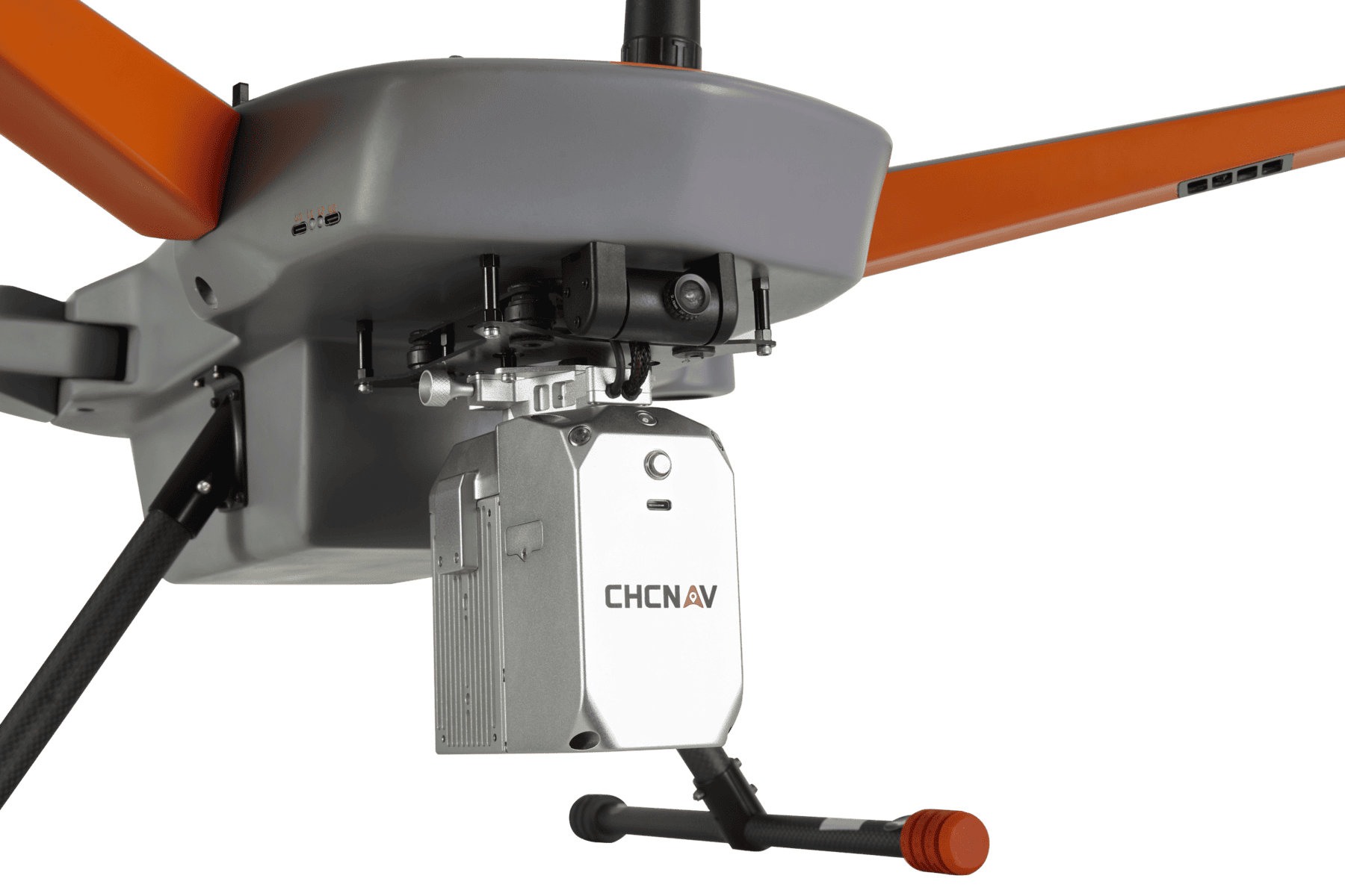
Switchable Payload: Another key feature of the BB4 mini is its switchable payload system. This innovation simplifies the process of changing the payload, which can include different LiDAR options, oblique cameras, ortho cameras, and more. The ability to switch payloads quickly and easily means that the UAV can adapt to a variety of tasks without the need for extensive reconfiguration.

Simple Operation and Portability: The BB4 mini is designed with user-friendliness in mind. It can go from being unpacked to airborne in less than five minutes, making it a highly efficient tool for professionals in the field. The design features detachable legs and a foldable arm structure, which not only minimizes storage space but also simplifies transport. The lightweight frame and modular design are complemented by a robust transport case, ensuring that it can be carried and towed with minimal effort.

Intelligent Operation: The UAV’s intelligent operation extends to mission planning and control. Users can plan missions on a desktop PC or a remote field controller using CHCNAV’s self-designed GS Control software. The terrain-following function simplifies flight planning by utilizing data from the cloud, ensuring that the drone maintains optimal altitude and avoids obstacles. The intuitive interface also provides easy access to drone and payload controls, enhancing the overall user experience and flight efficiency.

Flight Control Sensor Redundancy: Safety and reliability are paramount in UAV operations. The BB4 mini takes this seriously with extensive redundancies and safety mechanisms. Dual flight control system sensors, dual control signal links, dual intelligent batteries, and dual transmission links all work together to maximize flight safety and ensure critical missions can continue even in unexpected scenarios.

The BB4 mini quadrotor UAV is a comprehensive solution that brings together cutting-edge technology, precision data acquisition, extended endurance, adaptability, ease of use, and safety. It redefines the capabilities of UAVs for surveying and mapping applications and provides professionals with a powerful tool for their fieldwork.

Reviews

There are no reviews yet.

Be the first to review “CHCNAV BB4 Mini Survey Drone – Photogrammetry and LiDAR”

Your email address will not be published. Required fields are marked *