

Before a single foundation is poured or excavator breaks ground, construction surveying establishes the framework that transforms blueprints into reality. Accurate surveying ensures every element lands exactly where it should. In this guide, we’ll walk through what construction surveying involves, the methods that drive it, and the equipment that makes precision possible in the field.
What is Surveying in Construction
How Construction Surveying Works
Construction Surveying Equipment
Choosing the Right Equipment for Your Project
Why Construction Surveying Matters
The Bottom Line
Construction surveying is the process of measuring, mapping, and marking a site to guide physical construction according to design plans. It translates the architect’s drawings and engineer’s specifications into real-world coordinates that construction crews can follow. Surveyors establish boundaries, set elevations, mark utility placements, and verify that every phase of construction aligns with the original design intent.
Construction surveying happens throughout a project’s lifecycle: before groundbreaking to map existing conditions, during construction to guide layout and verify progress, and after completion to confirm the built work matches specifications. Without it, you’re building blind. With it, you reduce costly errors before they happen.
The core objectives of construction surveying include:
When done right, construction surveying prevents mistakes that would otherwise require expensive rework or compromise structural integrity.
The surveying process follows a logical sequence that begins with preparation and extends through project completion. Surveyors start by studying construction documents, blueprints, and site plans to understand layout requirements and identify critical reference points. They establish control points across the site that serve as fixed markers for all subsequent measurements, ensuring consistency as the project progresses.
A topographic survey maps existing site conditions including elevation changes, vegetation, existing structures, and natural features that could impact construction. This baseline data informs grading plans and helps identify potential obstacles before work begins.
From there, surveyors perform layout and staking, physically marking where crews should excavate, pour concrete, or install utilities. Stakes, flags, and paint marks translate coordinates into visual guides that equipment operators and laborers can follow without interpreting complex plans.
Throughout construction, surveyors maintain both vertical and horizontal control. Vertical control ensures structures sit at the correct elevation and grade, while horizontal control confirms alignment and positioning relative to property lines and other site features. As work progresses, periodic surveys verify that construction matches design specifications before moving to the next phase.
The accuracy of construction surveying depends on the tools used in the field. Modern surveyors rely on a combination of traditional instruments and advanced technology to deliver centimeter-level precision across sites of any size.
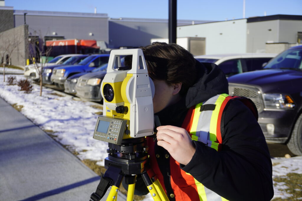
These remain the workhorse of construction surveying. Such electronic instruments measure both angles and distances simultaneously, allowing surveyors to pinpoint locations with extreme accuracy. They’re essential for setting control points, performing layout work, and verifying that structures align correctly. Total stations require line of sight to their target, but they deliver consistent results in environments where satellite signals struggle.
Real-time kinematic positioning uses satellite signals from GPS, GLONASS, Galileo, and BeiDou to determine positions within centimeters. RTK equipment like the Hemisphere S631 or GeoMeasure Nano 7 allows surveyors to establish points quickly across open sites without needing sight lines between stations. For road construction, subdivision layout, or any project spanning significant acreage, GNSS RTK dramatically improves efficiency compared to traditional methods.
Programs like FieldGenius allow surveyors to input design data, control equipment, and record measurements in real time. Modern field software can import CAD files directly, letting surveyors navigate to design points and stake them without manual calculations. This integration reduces errors and speeds up fieldwork considerably.

Automatic and laser levels help establish benchmarks and verify that grading, foundations, and structural elements sit at the specified height. For projects where drainage and slope matter, like parking lots or building pads, precise leveling prevents water management problems down the road.
Work best for angle measurements and quick elevation checks, especially on smaller projects or in situations where electronic equipment isn’t practical. Robotic total stations take this further by allowing a single surveyor to operate the instrument remotely, improving productivity when crew size is limited.
Not every construction site needs the same surveying setup. Small residential projects might get by with a total station and basic leveling equipment, while a highway construction project demands GNSS RTK systems that can cover miles of corridor efficiently. The key is matching your equipment to your site conditions and project requirements.
When selecting surveying equipment for construction projects, consider these factors:
Modern survey equipment should connect seamlessly with your design files and construction management software. When your data collector can import site plans directly and export coordinates to machine control systems, you eliminate transcription errors and keep the entire team working from the same information.
Construction surveying prevents problems before they become expensive mistakes. When foundations are poured in the wrong location or at the wrong elevation, the cost to fix it often exceeds the cost of the surveying that should have caught it.
Beyond cost savings, surveying directly impacts project safety and compliance. Building codes and regulations require structures to meet specific setbacks, elevations, and alignments. Surveying provides the documentation that proves compliance and protects you from legal disputes over property boundaries or construction defects.
For contractors, surveying improves efficiency by giving crews clear, accurate guidance:
Good surveying keeps projects moving forward without delays caused by measurement errors or uncertainty about where work should happen.
Construction surveying bridges the gap between design and reality. It takes plans off paper and marks them on the ground where construction actually happens. With the right equipment and proper technique, surveying ensures your project builds true to specifications, meets code requirements, and avoids costly errors.Investing in quality surveying equipment and understanding proper surveying methods pays off throughout the project lifecycle. At Bench-Mark, we work with contractors and developers across the U.S. to provide the GNSS RTK systems, total stations, and field software that make accurate construction surveying possible. Because when your layout is right from the start, everything that follows gets easier.
