

Every coordinate you collect in the field, every map you deliver to a client, every drone survey that gets turned into a usable deliverable rests on one foundational question: where, exactly, are you?
That’s the problem ground control points exist to solve, and it’s a problem that becomes far more consequential the larger and more precise your project needs to be. Positional drift, atmospheric interference, satellite geometry, and the inherent limitations of standalone GPS can silently corrupt your data before you ever open it in software. GCPs are the mechanism that catches that drift and pulls your data back to reality.
What Are Ground Control Points?
Ground Control Points in Surveying
Ground Control Points for Drone Mapping
How GCPs Are Measured
The One Thing That Can’t Be Fixed in Post
Ground control points are physical locations on the ground with precisely known coordinates, northing, easting, and elevation, that serve as fixed reference anchors in a survey. They are measured using high-accuracy GNSS equipment, such as an RTK receiver, to establish their true position on Earth. When that data is later processed, whether from a drone, a total station, or another instrument, the software ties the collected data to those known points, correcting any positional offset and producing an accurately georeferenced output.
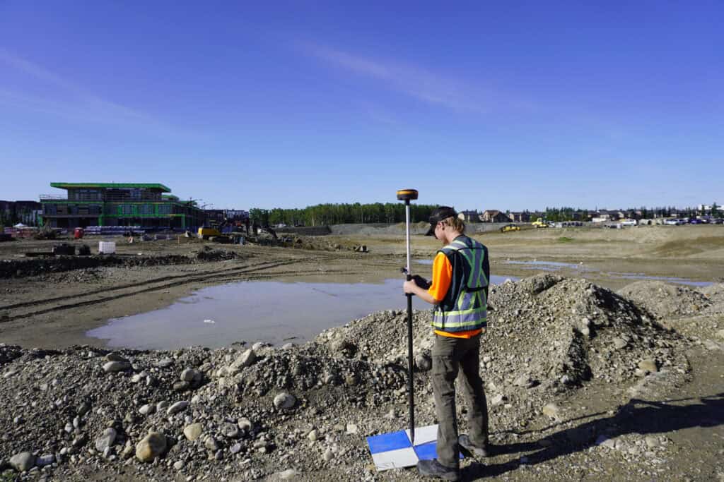
Physically, GCPs are usually flat, high-contrast markers, most commonly a black-and-white checkerboard or similar pattern. The geometry is deliberate: the sharp edges and contrasting blocks eliminate ambiguity about where the actual measurement point is. A spray-painted X, by comparison, has a “center” that could shift by 10 centimeters depending on interpretation, enough to meaningfully affect your results.
What separates a GCP from a manual tie point is absolute accuracy. A tie point improves relative accuracy by helping stitch images together consistently, but its location in the real world is undefined. A GCP, on the other hand, is the ground truth. When it comes to absolute positioning, the kind that surveyors, engineers, and clients are held to, GCPs are what close the gap between what the drone or instrument saw and where those features actually exist on Earth.
In traditional land surveying, the concept behind GCPs is as old as the discipline itself: you need known reference points to anchor unknown ones. Modern RTK GNSS systems have dramatically reduced the time and labor required to establish those references, but the underlying principle hasn’t changed.
For ground-based survey work, GCPs establish the coordinate framework that everything else is measured against. They define the datum, the projection, and the accuracy ceiling for the entire project. Without them, even the most sophisticated RTK rover is only as good as its network correction, and network corrections can fail, drift, or be unavailable in remote areas.
For construction, road, and subdivision projects, the consequences of poor control are severe. Horizontal errors compound across large sites. Elevation errors cause drainage problems. Boundary disputes arise from coordinates that looked right but weren’t tied to verified control. GCPs aren’t bureaucratic overhead, they’re how you protect the integrity of your deliverable.
Drone mapping introduced a new layer of complexity to an already precise discipline. A drone can capture thousands of images in an hour, and photogrammetry software can stitch those images into a rich, high-resolution 3D model or orthomosaic. But all of that processing is meaningless if the final product isn’t accurately georeferenced.
When a drone without RTK or PPK capability captures imagery, its onboard GPS is only accurate to a few meters. That’s fine for a visual inspection, but nowhere near sufficient for survey-grade deliverables. GCPs solve this by giving the photogrammetry software known anchor points to stretch and pin the model against. The software doesn’t guess where things are, it’s told, precisely, where the GCPs are, and it aligns everything else accordingly.
Key principles for GCP placement in drone mapping:
For RTK and PPK-equipped drones, the number of required GCPs drops significantly, often to 4–5 for a square mile, but they’re still valuable for quality control. There’s an important distinction between a GCP and a checkpoint here: GCPs are used during processing to constrain the model, while checkpoints are used after processing to verify it. Using only GCPs gives you an optimized-but-biased accuracy estimate; adding independent checkpoints gives you an honest one.
The “doming” effect is one of the more common errors in drone mapping, a subtle bowl-shaped distortion that results from inadequate vertical control. It’s almost invisible in the model but shows up in elevation data and volumetric calculations. Placing GCPs across varying elevations, rather than only at the perimeter, is the most reliable way to prevent it.

Placing the physical marker is only half the job. The coordinate that gets assigned to it is what actually matters, and that measurement needs to be accurate to the same standard you’re trying to achieve in the final product.
The standard workflow uses an RTK GNSS receiver placed directly over the GCP’s center point on a leveled pole at a known height. The receiver connects to a base station or GNSS network to apply real-time corrections, logging the position until the required accuracy is achieved. For PPK workflows, the raw GNSS data is collected in the field and processed afterward against a nearby base station.
Precision at this step matters more than anything else. A GCP that’s measured poorly becomes a hard constraint pulling your data in the wrong direction. The software trusts it completely. At Bench-Mark, we work with surveyors who run RTK control on sites where the final deliverable will be scrutinized, and the emphasis is always the same: verify your setup, check your network connection, confirm your accuracy before you walk away from the point.
You can reprocess a photogrammetry project. You can re-run a network adjustment. You can revisit a site and collect more data. What you can’t fix after the fact is a fundamental error in your control, a GCP that was measured off-center, a marker that moved between flight and measurement, or a control network that wasn’t verified against an independent checkpoint.
Ground control points are the part of a survey workflow where discipline and field craft matter most. Bench-Mark customers are working with some of the most capable RTK equipment available in North America, but no hardware substitutes for methodical, verified control.
Accuracy is not a software feature. It’s built into the field, one known point at a time.
