
GNSS rover is the crucial tool in the field, but with all the models, features, and software options out there, it’s easy to get overwhelmed. This guide breaks down what a GNSS rover actually does, what components matter, and how to choose the right setup for your workflow and budget.
What Is a GNSS Rover?
What’s in a GNSS Rover Kit?
How Does a GNSS RTK Rover Work?
Choosing the Right GNSS Rover: 5 Key Factors
How Much Does a GNSS Rover Cost?
Your Rover, Your Workflow
Frequently Asked Questions
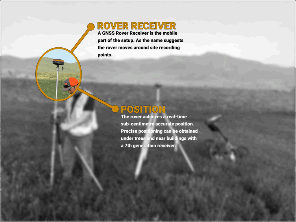
A GNSS rover is a mobile receiver that works with satellites and often a base station. It calculates precise positions in the field. “GNSS” stands for Global Navigation Satellite System, which includes GPS, GLONASS, Galileo, and BeiDou constellations. If you’re working with RTK GPS & GNSS Systems, you’re already at a decent level of precision.
If you get the correct setup, a GNSS rover can deliver to you centimetre-level accuracy in real time.
Most GNSS rover kits include:
At Bench-Mark, we build and support kits with these parts dialled in for real-world use.
When you decide to use a GNSS RTK rover, you’re getting real-time corrections from a base station or network. Here is how it gives you maximum accuracy:
This is how you get the precise surveying with no need to process data post-fieldwork. Just collect, export, and go.
Our Hemisphere S631 delivers reliable RTK precision. It is the basis of most new rover sales. It’s rugged, easy to use, and budget-friendly compared to Trimble or Leica.
Your pole may not even be perfectly vertical and you still can measure. Modern rovers like the GeoMeasure Nano 7 include inertial sensors (IMU) that let you tilt up to 60° with the same accuracy. It’s great for working on slopes, in trenches, or around obstacles.
Your data collector and field software must work together. We recommend FieldGenius, developed by MicroSurvey. It is stable, has clear interface, and power-user features. It runs on Windows-based data collectors and works with all our GNSS receivers.
Depending on your workflow and location (urban, rural, remote), the right modem can impact the workflow. For example, the S631 offers multi-mode connectivity (cellular, UHF radio, and both). It doesn’t mean where the job takes, you’re always covered.
With many GNSS suppliers, once the gear ships, you’re on your own to deal with it and explore its functions. However, we at Bench-Mark can offer support for surveyors across Canada and the US. We operate from a single central office, selling and supporting systems online nationwide, which means you just get straight answers from us.
GNSS rover sets typically range from $3,000 to $14,000 CAD, depending on:
Low-cost rovers like Emlid have driven prices down, but they often come with limited support and not that stable performance. If you need gear that works right and lasts more than a season, you’re better off with a proven kit like the S631 or Nano 7.
Choosing the right GNSS rover means paying attention to both specs and how you work. At Bench-Mark, we’ve spent over a decade helping surveyors, engineers, and construction pros find the right fit for their projects, their crews, and their budget.
Want to learn more about what makes a great GNSS rover kit? Check out our full selection of RTK GPS & GNSS Systems, or give us a call. We will help you to build a kit that works for you.
“GPS” refers to one satellite system (from the US), while “GNSS” includes all global systems. Modern rovers use GNSS for better coverage and reliability.
Yes, if you’re using a correction service (like NTRIP). But for full control and redundancy, many users prefer owning a rover + base station kit.
An IMU lets you collect data when your pole is tilted. If you’re working around buildings, slopes, or obstacles, it’s a worthwhile upgrade.
For basic work, maybe. But if accuracy, uptime, and support matter, we recommend sticking with proven systems like the Hemisphere S631 or GeoMeasure Nano 7.
The best way to ensure accuracy is to monitor RTK fix status, satellite count, and horizontal/vertical precision (HRMS/VRMS) values in your field software. A good fix should have low HRMS (under 0.02 m), high satellite visibility (12+), and maintain a consistent RTK fix.
