

If you’re looking at upgrading your drone fleet for surveying, mapping, or inspection workflows, there’s a good chance the new DJI Matrice 400 RTK has caught your eye. And if you’re already running a DJI Matrice 350 RTK, you might be wondering what’s the difference.
We’ve gathered some details into both platforms to help surveyors and geospatial professionals understand what’s changed, what’s improved, and what it means for your work in the field. This guide breaks down the major differences that matter on real jobsites.
Flight Time & Performance
Payload Capacity & Workflow Flexibility
RTK Accuracy & Workflow Enhancements
Battery System
Remote Controller
Mapping & Survey Workflows
Which One Should You Choose?
Final Thoughts
Frequently Asked Questions
Before diving into the details, here’s a quick side-by-side look at how the two platforms compare on the specs, features, and pricing that matter most:
| Category | DJI Matrice 350 RTK | DJI Matrice 400 RTK |
| Max flight time (w/payload) | 44 min | 59 min |
| Max payload capacity | 2.7 kg (1 payload) | 6 kg (up to 7 payloads) |
| Video transmission | O3 Enterprise | O4 Enterprise, with dual cellular and airborne relay support |
| Battery system | TB65 dual-battery, hot-swappable | TB100 single-battery, hot-swappable, tethered power option |
| Intelligent flight modes | Basic waypoint and terrain awareness | Cruise, FlyTo, Smart Track, POI, Ship Takeoff, real-time Terrain Follow |
| Starting price | Lower upfront cost | Higher upfront cost, roughly $10,000+ for the aircraft body alone |
| Ideal use case | Standard mapping, inspection, and RGB/thermal capture on a budget | Corridor mapping, multi-payload missions, and complex or large-scale operations |
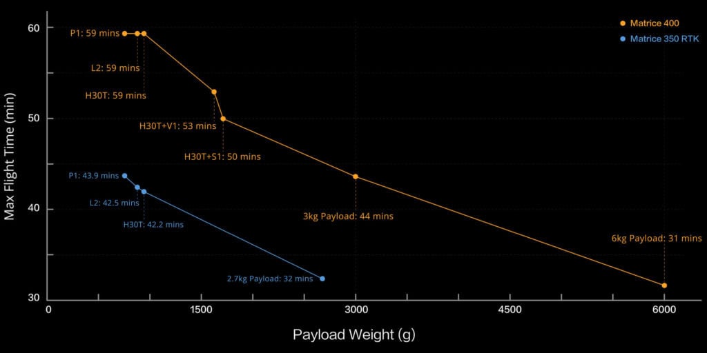
The most obvious and immediate difference is the flight time. The DJI Matrice 400 RTK boasts a max time of 59 minutes (with payload), compared to the 44 minutes of the Matrice 350 RTK. It’s just 15 extra minutes, but per flight it adds up fast. Especially for corridor mapping, LiDAR passes, or orthophoto capture over large areas.
| Spec | DJI Matrice 350 RTK | DJI Matrice 400 RTK |
| Max Flight Time | 44 min (w/payload) | 59 min (w/payload) |
| Max Speed | 15.6 m/s | 25 m/s |
| Max Transmission | 20 km | 40 km |
The speed and range boosts make the Matrice 400 RTK more suitable for high-efficiency topographic mapping, especially when you need to cover large areas and there’s not much time left.
Beyond top speed, the Matrice 400 RTK also climbs and descends faster, with a max ascent speed of 10 m/s and a max descent speed of 8 m/s, compared to the Matrice 350 RTK’s 6 m/s ascent and 5 m/s vertical descent. Route speed follows the same jump, with the M400 flying pre-planned missions roughly 60% faster than the M350. For corridor and topographic mapping, this combination means fewer battery swaps, more ground covered per flight, and less time spent waiting for the drone to climb, descend, or reposition between waypoints, all of which adds up to more completed missions per day.
Both platforms use DJI’s Enterprise transmission systems, but the Matrice 400 RTK’s O4 Enterprise system is a meaningful step up from the Matrice 350 RTK’s O3 Enterprise. The O4 system supports smoother 1080p video at up to 60 fps across three simultaneous channels, compared to 30 fps on the O3 system, which matters most when reviewing footage in real time during inspection or public safety missions.
The Matrice 400 RTK also adds dual 4G cellular dongle support, giving crews a cellular backup connection when radio-frequency transmission is degraded by terrain, buildings, or distance. Its Airborne Relay Mode goes a step further, letting one Matrice 400 act as a signal bridge for a second drone, which keeps command and video links alive in canyons, mountainous terrain, or other environments where a direct line of sight isn’t possible. Between the O4 system, dual cellular support, and airborne relay, the Matrice 400 RTK is built to hold a reliable signal in conditions that would challenge the Matrice 350 RTK’s O3 setup.
The Matrice 350 RTK supports 1 payload up to 2.7 kg, which works well for standard camera or LiDAR setups. The DJI Matrice 400 RTK steps it up with support for up to 7 payloads and 6 kg total capacity. It also introduces 4x E-Port V2 interfaces. It makes run LiDAR + RGB + thermal simultaneously possible. Here are the new opportunities:
Both platforms support RTK positioning, but the Matrice 400 RTK outstands owing to the better real-time terrain following and multi-point route planning. It’s particularly valuable for topographic and corridor mapping and when working near slopes, rivers, or complex terrain. Here is what 400 possesses and 350 lacks in this aspect:
These features allow you to automate more of the flight, reduce pilot workload, and increase consistency between flights. Let’s say, if you are flying a linear corridor for utility or pipeline inspection, Power Line Follow + RTK + Terrain Follow can reduce rework and simplify post-processing in tools like DJI Terra or FieldGenius.
Looking closer at what these tools actually do in the field: Smart 3D Capture generates a rough 3D model of the survey area with a visual route preview before you fly, so you can confirm coverage before committing battery life to the mission.
Real-time Terrain Follow keeps the aircraft at a constant height above the ground even on sloped or uneven sites, which keeps ground sampling distance consistent across the whole dataset instead of drifting as elevation changes.
The onboard AI, powered by the Manifold 3 computer, handles object and obstacle recognition in real time, which is what allows features like Power Line Follow to navigate around crossing wires without constant manual correction.
FlightHub 2, DJI’s cloud-based fleet management platform, ties all of this together by letting teams plan automated missions, monitor flights remotely, and sync captured data and live annotations across a whole fleet, rather than managing each mission and dataset in isolation.
Beyond RTK and mapping-specific tools, the Matrice 400 RTK introduces a set of intelligent flight modes designed to reduce pilot workload on longer or more repetitive missions:
Together, these modes reduce the amount of manual flying required on repetitive or high-risk missions, which translates directly into fewer pilot errors and more consistent data across flights.
Battery management is one of the most painful parts of drone operations. DJI took a huge step forward with the M400’s TB100 batteries. Let’s look closer at the spcs in the table.
| Spec | Matrice 350 RTK | Matrice 400 RTK |
| Battery Capacity | 5,880 mAh | 20,254 mAh |
| Energy | 263.2 Wh | 977 Wh |
| Tethered Power | No | Yes |
| Charging Time (220V) | 60 min | 45 min |
| Smart Battery Station | No | Yes |
In practice, it means that with fewer battery swaps and charging you get longer uninterrupted missions and shorter turnaround time. Tethered support provides you continuous power for stationery ops like monitoring, scanning, or overwatch.
Both drones use a smart controller with a 7.02” screen, but the M400’s 1400-nit brightness performs particularly well on sunny job sites. Backlit keys help when you’re flying in low light or early morning/late evening.
The controller also supports a sub-2G antenna extension. This enhances live feed quality in low signal environments, which is ideal for mountainous, forested, or urban survey areas.
The DJI Matrice 400 RTK is made for mapping missions if you pair it with the right payloads:
Add in DJI Terra and DJI Modify for back-office processing, and you have a full-stack mapping solution.
Where the Matrice 350 RTK still shines:
The DJI Matrice 400 price sits noticeably higher than the Matrice 350 RTK, with the aircraft body alone typically running upwards of $10,000 before payloads, batteries, or accessories are added. That’s a meaningful jump, and it’s fair to ask whether the extra cost pays for itself.
For teams running standard single-payload missions, basic RGB or thermal capture, or working with tight budgets, the Matrice 350 RTK still delivers strong value relative to its price. But for operations that regularly run multi-payload missions, long corridor mapping, or need the extra flight time and transmission reliability, the ROI case for the Matrice 400 RTK is straightforward: fewer flights per project, less battery-swap downtime, and the ability to capture LiDAR and RGB data in a single pass instead of two separate missions. For teams billing by the project rather than the hour, that efficiency gain often offsets the higher purchase price within a handful of jobs.
In short, the upgrade tends to make the most financial sense for teams whose workload has already outgrown a single-payload, shorter-endurance platform, not for teams whose missions are already well served by the Matrice 350 RTK.
Bench-Mark considers all the requirements, so we are ready to give expert advice on multiple options. If you’re a budget-conscious team just getting started with aerial mapping or inspections, the DJI Matrice 350 RTK still would be a worthwhile options. It’s well-suited for shorter missions, standard RGB or thermal data collection, and simpler workflows where automation and extended payload capacity aren’t essential.
When you are working on corridor mapping, large-scale topographic surveys, or multi-payload missions (such as LiDAR plus RGB capture in a single flight), the DJI Matrice 400 RTK is the clear choice.
Same thing for professionals who need to combine mapping and inspection tasks into a single deployment or operate in challenging environments where tethered power or long-range communications are critical. The Matrice 400 RTK provides capabilities the 350 simply can’t match.
Broken down by role, here’s how that guidance plays out for different types of teams:
Upgrading makes sense if your current missions are limited by battery swaps, single-payload constraints, or signal range, especially for corridor mapping, utility inspection, or public safety work where the Matrice 400 RTK’s extra endurance and connectivity translate directly into fewer flights and more reliable data.
The Matrice 350 RTK remains the better choice if your workflows are already well served by a single payload, shorter mission lengths, and standard RGB or thermal capture. Its lower cost, mature software ecosystem, and proven track record still make it a sound investment for teams that don’t need the Matrice 400 RTK’s added payload capacity or automation.
Our opinion at Bench-Mark is that the DJI Matrice 350 RTK is still a fine choice for standard mapping and inspection work. But the Matrice 400 RTK gets you clear advantages for professionals who need longer flights, greater payload flexibility, and advanced automation.
Yes, if your workflow includes larger areas, dual payloads, or complex mapping automation. The improvements in battery life, payload capacity, and terrain-following make a real difference.
Most Zenmuse payloads are compatible, but the M400 supports more simultaneous payloads and better integration for LiDAR + RGB workflows.
Yes. It supports more advanced terrain tracking, RTK initialization, and automation for repeatable accuracy over large sites.
Surveying, civil engineering, power line inspection, public safety, and any workflow needing great mapping or 3D deliverables.
Yes. At Bench-Mark, we provide full system integration, training, and ongoing support.
