

In the world of land surveying, achieving pinpoint accuracy is essential. Real Time Kinematic (RTK) Global Navigation Satellite Systems (GNSS) have made surveying more efficient, but their ability to get around terrain or long distances with just UHF radio can sometimes leave the surveyor stuck in a ditch. This is where network correction services come into play, helping surveyors enhance the precision of their positioning systems using a cellular network instead of UHF. Among the most widely used correction methods are Virtual Reference Stations (VRS) and Nearest Point Networks (often referred to as single-base corrections).
Understanding the key differences between these two systems is vital for surveyors to make the right choice for their projects, depending on factors such as project scale, accuracy needs, budget constraints, and available infrastructure. This article provides a comprehensive comparison of VRS and Nearest Point Networks, diving deep into their functionalities, advantages, and limitations, to help surveyors select the best option. Don’t want to read? Check out our video below:
Virtual Reference Stations (VRS): Work Anywhere
Disadvantages of a VRS Network
Nearest Point Network (Single-Base Correction)
Advantages of Nearest Point Network
Disadvantages of Nearest Point Network
When to Choose Nearest Point Network
Technological Trends and Future Considerations
Key Differences Between VRS and Nearest Point Networks
A Virtual Reference Station (VRS) is a correction service that uses a network of continuously operating GNSS reference stations (CORS) to create a virtual base station near the user’s rover. Using the best GPS survey equipment ensures surveyors can take full advantage of VRS accuracy. This technique is typically part of a Real-Time Kinematic (RTK) Network and is designed to provide highly accurate positioning data to surveyors.
VRS networks are especially suited for covering large areas, with many nationwide networks using a backbone built upon VRS software. Networks include not only subscription based networks like Leica’s Smartnet and Trimble’s Cannet, but also public networks like Ohio’s ODOT VRS and South Carolina’s SCRTN networks.
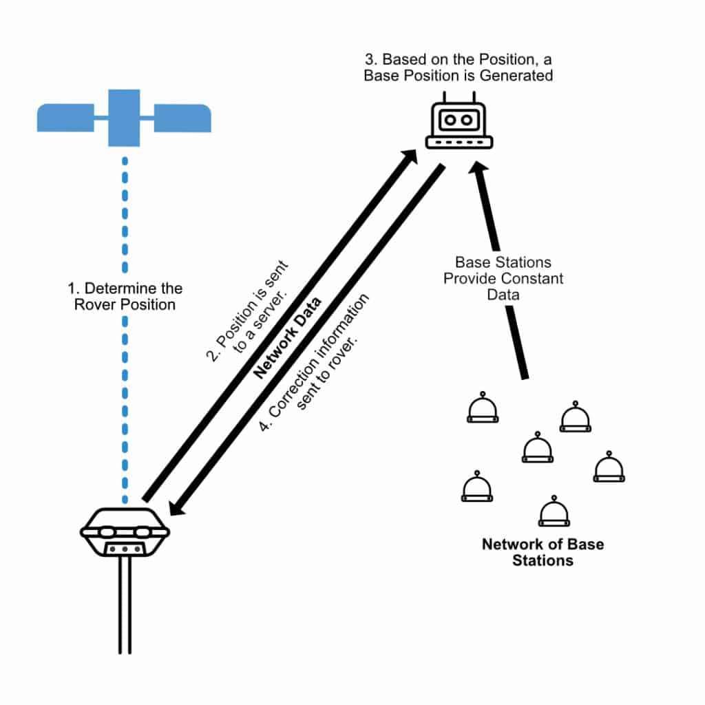
How a VRS System Works
The concept behind VRS is on paper very simple. A central server collects all available data from a network of base stations locations. This data is then input into a computer program to simulate the presence of a physical reference station near the GNSS rover, even though no such physical station exists on-site. The server then transmits data based on this simulated position to the rover, allowing it to calculate a fixed position. The VRS system uses the following process:
Enhanced Accuracy Across Large Areas
The biggest advantage of VRS is its ability to provide consistent accuracy across a wide area. By generating a virtual reference station close to the user, it minimizes errors that increase with distance from a physical base station. For operators working over a large area this can help keep data consistent from site to site.
Convenience and Reduced Equipment Since the system creates virtual reference stations, surveyors no longer need to set up their own physical base stations. This simplifies gear requirements, reduces setup time, and decreases the amount of gps land survey equipment required for the job. For operators who need to visit multiple sites every day, this is a great solution.
Subscription Costs
Depending on where you are, access to a VRS networks can come with a subscription fee, which can be costly. For smaller firms or projects with limited budgets, these fees can become incredibly taxing as they add up year after year for a project. We have had users with over $35,000 a year in subscription costs, who switched away from a VRS due to these costs.
Network Dependency
The capabilities of a VRS network can be heavily dependant on factors out of a surveyor’s control, such as network base issues or downtime, or changes in position day to day if the network drifts. These issues are the hardest to overcome because they are out of your hands and put you at the mercy of the staff operating the VRS network.
High Infrastructure Requirements:
VRS networks rely on a dense array of GNSS base stations, sophisticated central servers, and reliable data connections. Depending on the network, coverage may not be available in more rural or remote areas, making it hard to do work outside of urban centers. On top of this, as technology progresses, the larger the number of base stations in a network the higher the cost to upgrade. This means that technology can be out of date, not giving you the best performance.
The Nearest Point Network, often referred to as single-base correction service, uses correction data from the closest physical reference station to the rover. This approach is still widely used, especially in areas without VRS network coverage, or where higher accuracy and redundancy is required. Corrections can be broadcast over either UHF or via cell networks. For the network component we obviously need to use a cell network. An example of a service that allows you to run your own Point to Point network is StormCaster.
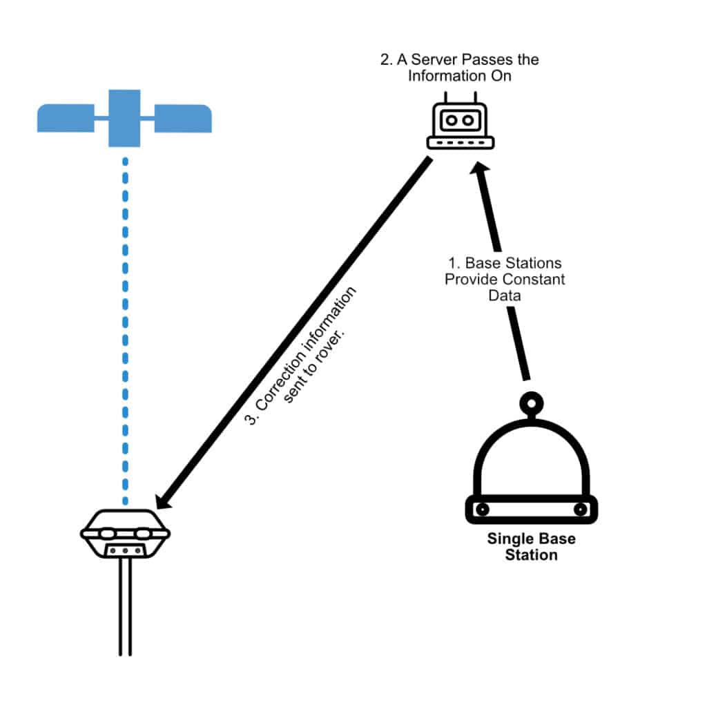
How Single-Base Correction Works
In a single-base correction system, just like a standard base and rover setup, a GNSS base station is installed at a known, fixed location. The base station continuously tracks GNSS satellite signals and sends out correction data for rover use. This data is then transmitted to the rover in real time. Here’s how the process works:
Simple and Easy to Use
Single-base systems are straightforward to set up and operate. Surveyors only need access to one base station, making this a convenient solution for surveyors who have the majority of their work in a local area, or a long-term job site that could have a permanent base setup.
Lower Cost
Since single-base systems don’t rely on an extensive network of base stations so they are often significantly less expensive than a VRS system. This makes them a good choice for smaller firms or projects with limited financial resources but many machines on site. The software that is required to run a VRS network can cost upwards of $100,000.
Availability in Remote Areas
In regions where VRS networks are unavailable or impractical, single-base correction can still provide reliable positional data, with a much simpler deployment procedure. This means that smaller communities or municipalities can deploy a single point reference station much quicker than building up the resources to implement a VRS.
Accuracy Diminishes with Distance
The primary drawback of single-base systems is that their accuracy decreases as the rover moves farther away from the reference station. This is due to spatial decorrelation, where satellite signal errors (such as atmospheric delays) differ over longer distances. This means that a single-base system is not suited for survey firms that send their crews over a large area to do work. See our video below on accuracy at distance.
Large-Scale Projects
One of the primary advantages of VRS systems is their ability to deliver consistent accuracy across large geographical areas. For projects that cover extensive regions, such as infrastructure development, VRS is an ideal choice. The system’s ability to create virtual base stations near the rover ensures that accuracy is maintained regardless of the rover’s movement across the project.
Urban Areas with Strong Network Coverage
Urban areas often have strong network coverage for VRS and great cell network coverage, making VRS a great choice for large projects in densely populated cities. VRS networks are particularly well-suited to urban environments, where multipath errors and signal interruptions are common due to tall buildings and dense infrastructure. Because VRS uses data from multiple reference stations in the area, it can mitigate these errors better than single-base systems, which rely solely on data from the nearest reference station.
Small or Localized Projects
For small projects with limited geographical scope, a single-base correction system is often sufficient. Tasks such as boundary surveys, site layout for smaller construction projects, or agricultural mapping can be completed using a single reference station. As long as the rover stays within a reasonable distance of the base station (typically up to 10-20 kilometers with a 7th generation RTK receiver), accuracy will remain high enough for most practical applications.
Remote or Rural Areas
In areas where VRS network infrastructure is sparse or unavailable, single-base systems provide a reliable alternative. Rural and remote regions, where VRS coverage is limited or nonexistent, can still benefit from high-accuracy GNSS corrections using local reference stations.
Budget-Conscious Projects
Single-base correction systems are generally less expensive than VRS, making them an attractive option for projects with tight budgets. For organizations that cannot afford the subscription fees associated with VRS networks, single-base systems provide an affordable way to achieve reasonably accurate positioning without breaking the bank.
As GNSS technology continues to evolve, both VRS and single-base correction systems are becoming more sophisticated. Advances in satellite constellations, such as the addition of new GNSS signals from systems like Galileo or BeiDou and the addition of forward error correction on GNSS signals, are improving the overall availability and accuracy of satellite positioning data. These improvements are expected to enhance both VRS and single-base systems in the coming years.
Integration with UAVs and Automation
Surveying technology is also advancing rapidly in the areas of automation and unmanned aerial vehicles (UAVs). Both VRS and single-base correction systems are being adapted for use with UAVs, which can carry GNSS receivers and other gps land survey equipment to collect topographic data over large areas. As drone technology becomes more integrated into land surveying workflows, the demand for accurate, real-time corrections will continue to grow, and both VRS and single-base solutions will play important roles in supporting these automated systems.

While both VRS and Nearest Point Networks provide GNSS corrections, they do so in fundamentally different ways. Here’s a detailed comparison of the two:
| Feature | VRS | Nearest Point Network |
| Correction Source | Virtual reference station created near the rover. | Nearest physical reference station. |
| Accuracy | Uniform accuracy over a large area but is dependent on network coverage and performance. | Higher accuracy at short distances, but accuracy decreases with distance from the reference station. |
| Cost | While many areas have public VRS networks, private VRS networks often see expensive subscription costs. | Higher initial investment, but significantly lower long-term costs. |
| Coverage Area | Wide area, with consistent accuracy | Limited to ranges of ~20 miles (~32 km). |
| Ideal Use Case | Firms with a large range of work or very large projects. | Larger, more localized sites or projects. |
Both VRS and Nearest Point Networks offer valuable GNSS correction methods for land surveyors, but the choice between the two depends on specific project requirements. VRS excels in providing uniform coverage over large areas but comes with higher costs and infrastructure requirements. Nearest Point Networks, while simpler and more cost-effective, have limitations when it comes to accuracy over long distances and coverage areas.
For surveyors working on large-scale projects or in areas with good network coverage, VRS offers more uniform precision and ease of use. On the other hand, for small, localized projects or in regions where budget constraints or network availability are concerns, a single-base correction system can provide accurate results at a lower cost.
By understanding the strengths and weaknesses of each system, surveyors can make informed decisions that best meet their project needs, ensuring efficiency, accuracy, and cost-effectiveness in their work.
What kind of GPS do surveyors use?
Surveyors primarily use GNSS receivers capable of Real-Time Kinematic (RTK) positioning. These include dual-frequency or multi-frequency receivers from brands like Trimble, Leica, and Hemisphere, often paired with rovers, base stations, or VRS networks. For field flexibility, handheld GPS units designed for surveying can also be used.
How Accurate is GPS Surveying?
The accuracy of GPS surveying depends on the type of receiver and correction system used. Standard standalone GPS can have accuracies of 3–10 meters, while RTK GPS and VRS setups can achieve centimeter-level precision.
What is the most accurate GPS device for surveying?
The most accurate handheld GPS for surveying typically refers to multi-frequency GNSS receivers with RTK capability. These devices can achieve centimeter-level accuracy in real-time. The most accurate GPS for surveying will often include professional rovers from brands like Trimble, Leica, or Hemisphere, supporting multi-constellation signals (GPS, GLONASS, Galileo, BeiDou) for optimal precision.
Bench Mark Equipment & Supplies is your team to trust with all your surveying equipment. We have been providing high-quality surveying equipment to land surveyors, engineers, construction, airborne and resource professionals since 2002. This helps establish ourselves as the go-to team in Calgary, Canada, and the USA. Plus, we provide a wide selection of equipment, including global navigation satellite systems, RTK GPS equipment, GNSS receivers, and more. We strive to provide the highest level of customer care and service for everyone. To speak to one of our team today, call us at +1 (888) 286-3204 or email us at [email protected]
