

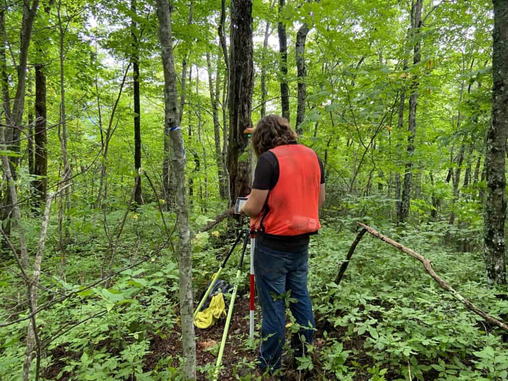
Surveying is the science of determining the positions of points on the Earth’s surface, and it plays a crucial role in various fields such as construction, mapping, and engineering. Understanding the relationship and difference between accuracy and precision are crucial in understanding your results and getting the most out of your equipment. Particularly in Real-Time Kinematic (RTK) base and rover surveying, understanding these concepts is essential for producing reliable and repeatable results.
While accuracy and precision are sometimes used interchangeably in everyday language, they have fundamentally different meanings. By understanding the difference, and how your equipment works will help you survey better in the field and fix errors on the fly. This article will explore the differences between accuracy and precision, their importance in RTK surveying, and how you can correct your position in the field through the use of techniques like localization and known position setups. Don’t like to read? Check out our video on this topic:
How Are Accuracy and Precision Related?
Accuracy and Precision in Surveying
Accuracy in Base and Rover Operation
Precision in Base and Rover Operation
Correcting Accuracy and Precision Issues
Accuracy in surveying refers to how close a measurement is to the true or accepted value. In other words, accuracy is a measure of correctness. When you take a measurement, you want it to reflect the actual position of a point on the Earth’s surface. High accuracy means that the measured position is very close to the actual position, or the “true” value regardless of the number of recorded measurements.
Examples of Accuracy in Everyday Life
To better understand accuracy, let’s consider a few examples from everyday life:
1. Dartboards
Imagine you are playing darts, and the bullseye represents the true position you are trying to hit. If your dart lands close to the bullseye, your throw is accurate. This is akin to taking a measurement in RTK surveying that closely matches the true geographic position.
2. Bathroom Scale
When using your bathroom scale to determine your weight, you rely on the accuracy of the scale to give an indication of your weight. If your scale provides a weight greater than the true value (a very common problem), you may falsely assume you have health problems. An accurate measurement will give you the best answer when your doctor (or spouse asks).
3. Thermometer Reading
Consider a thermometer that is supposed to read the true temperature. If the actual temperature is 72°F and the thermometer shows 72°F, it is accurate. If the weather app predicts no rain, and you arrive on site to a rainstorm, it is inaccurate.
In RTK surveying, accuracy is similarly about ensuring that the position data collected by your equipment is as close as possible to the true position on the ground. This is crucial in applications like construction, where even small errors can have significant consequences.
Boundary surveyors need a high degree of accuracy to ensure that property lines are properly set. With modern 7thgeneration receivers, surveyors can record position with a high degree of accuracy even under heavy canopy.
Precision, in contrast, refers to the consistency of repeated measurements. Precision is about the repeatability of measurements and how closely they agree with each other, irrespective of whether they are close to the true value.
Real-World Examples of Precision
Here are a few examples to illustrate the concept of precision:
1. Dartboard
Continuing with the dartboard analogy, imagine you throw three darts, and they all land outside the dartboard. However, all three darts are clustered together within an inch. Your throws are precise because they are consistent with each other, but they are not accurate because they are far from the target.
2. Bathroom Scale
After returning from vacation, your scale now reads 10 lbs heavier than before you left. After taking three weights, your scale is consistently 10 lbs heavier then when you left. Now we know we could not have possibly gained any weight after this trip, so we now know that the scale is no longer accurate, but it is precise as all measurements are very close to one another.
3. Thermometer Consistency
Imagine a thermometer that consistently reads 70°F, regardless of the actual temperature. It’s precise because it gives the same reading every time, but it is not accurate if the true temperature varies.
In RTK surveying, precision is crucial when you need reliable, repeatable measurements, such as when monitoring the movement of a structure over time. High precision ensures that the data collected over multiple sessions is consistent and repeatable, both of which are vital for detecting minute changes.
Now that we have seen the difference between accuracy and precision, how are the two related? It is possible to have a high degree of accuracy and low precision, or a high degree of precision and low accuracy. The below picture will give you a good idea of how the two relate.
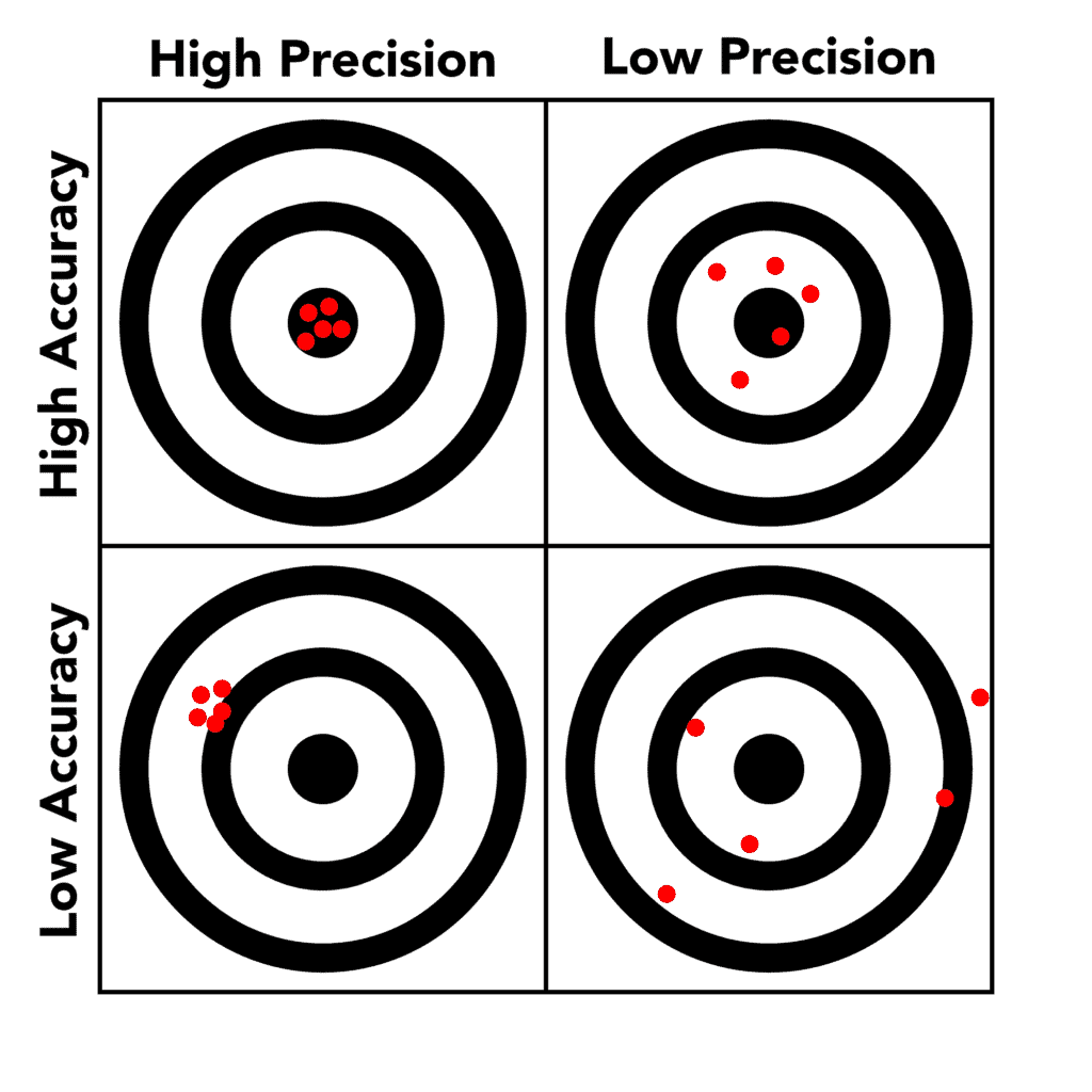
In RTK surveying, achieving both high accuracy and high precision is the ultimate goal. This combination ensures that your measurements are both close to the true positions and consistent with each other. However, if you do not understand how the equipment works, you will not understand what you are seeing.
Understanding the difference between accuracy and precision helps explain why both are important in RTK surveying. If your survey is only accurate but not precise, your measurements will be close to the true position, but they may not be consistent. This inconsistency can make it difficult to trust the data, especially if you are monitoring changes over time.
On the other hand, if your survey is precise but not accurate, your measurements will be consistent but systematically offset from the true position. This is problematic because it can lead to systematic errors in your project, such as misaligned structures or incorrect boundaries.
Achieving high accuracy and precision is essential for producing reliable survey data that can be used with confidence in decision-making processes. Let’s delve into how these concepts apply specifically to base and rover operations in RTK surveying.
RTK surveying relies on a base station and a rover to achieve high-accuracy measurements. The base station is a fixed point with known coordinates, while the rover is a mobile unit that collects data across the survey area. The base station sends correction data to the rover, which uses this information to improve the accuracy of its measurements.
The accuracy of your RTK survey is heavily dependent on the base station’s known position. The base station acts as a reference point, and its coordinates are assumed to be correct. If the base station’s coordinates are inaccurate, all the measurements taken by the rover will inherit this error. With an RTK Fix, your rover’s position should always be precise to one another. For 7th generation receivers, like the Hemisphere S631, some receivers employ two separate RTK engines
For instance, if you set up a base station at a location where the true coordinates are unknown or incorrect, all subsequent measurements made by the rover will be offset by the same amount as the error in the base station’s coordinates. This type of error is particularly problematic in large-scale projects where cumulative inaccuracies can lead to significant discrepancies.
To ensure accuracy, it is crucial to place the base station at a location with known, highly accurate coordinates. This can often be achieved by using benchmarks or points that have been previously surveyed with a high degree of accuracy. In cases where such points are unavailable, techniques like localization (discussed later) can be employed to improve the accuracy of the base station’s position.
Precision in RTK surveying is more about the quality of the equipment and the conditions under which the survey is conducted. Factors like satellite geometry, signal interference, and multipath errors (where signals bounce off surfaces before reaching the rover) can affect precision.
If the rover experiences signal interference, for instance, the measurements may vary slightly from one reading to the next, leading to a lack of precision. Even if the base station’s position is accurate, these small variations can make it difficult to produce consistent data.
To achieve high precision, it is important to:
1. Use High-Quality Equipment
Ensure that both the base station and the rover are of high quality and are capable of using all available satellite constellations and their respective signals. Check and ensure that you are using the best possible message type like RTCM 3.2MSM, Hemisphere’s ROX or Trimble CMRx.
2. Minimize InterferenceConduct surveys in open areas with minimal obstructions that could cause signal multipath errors. Buildings, trees, and other large structures can reflect satellite signals, leading to inconsistencies in the rover’s position data. Although the latest receivers can mitigate the effects of these obstacles, you can still see a decrease in performance.
3. Optimize Satellite Geometry
Satellite geometry, or the spatial arrangement of satellites relative to the receiver, plays a crucial role in precision. A better distribution of satellites (high PDOP, or Position Dilution of Precision) results in more reliable and precise measurements.
By focusing on these factors, you can improve the precision of your RTK survey, ensuring that your measurements are consistent and reliable.
Even with the best practices, there may be situations where accuracy and precision need to be corrected or improved. This is where techniques like localization and using a known base position setup come into play.
Localization
Localization is a process used to adjust the base station’s coordinates to match the local coordinate system. This technique is particularly useful when the base station’s true coordinates are not known with high accuracy, or when working in a localized project area where the coordinate system may differ from the global reference.
How a Localization Works
Localization involves measuring one or more known points in the survey area and comparing these measurements with the coordinates provided by the base station. The differences between the measured and known coordinates are used to adjust the base station’s position, effectively aligning the entire survey to the local coordinate system.
For example, if you are surveying a construction site, you might have a known benchmark point with established coordinates. By measuring this point with your RTK rover and comparing it to the base station’s data, you can identify any discrepancies and apply a correction to the base station’s coordinates. This adjustment ensures that all subsequent measurements are aligned with the local coordinate system, improving overall accuracy.
Localization is particularly valuable in projects where local accuracy is more important than global accuracy, such as in site-specific construction or engineering projects. By aligning your survey with known local points, you can ensure that your measurements are both accurate and relevant to the specific project area. Here are two guides on performing a localization in FieldGenius Windows and Android.
FieldGenius Windows Localization
FieldGenius Android Localization
Known Position Setup
Another effective method for ensuring accuracy and precision is the known position setup. This involves placing the base station at a point with precisely known coordinates, such as a geodetic control point or a previously surveyed benchmark.
Advantages of a Known Position Setup
1. Eliminates Systematic Errors
By using a known position, you eliminate the risk of introducing systematic errors into your survey. Since the base station’s coordinates are highly accurate, the rover can apply correction data more effectively, leading to more accurate measurements.
2. Simplifies the Survey Process
A known position setup simplifies the survey process by reducing the need for additional corrections or adjustments. Since the base station’s position is already accurate, you can focus on collecting data with the rover, confident that the measurements will be both accurate and precise.
3. Improves Reliability
Surveys conducted with a known position setup tend to be more reliable, as they are based on established and trusted reference points. This is especially important in projects where precision and accuracy are critical, such as in large-scale infrastructure projects or cadastral surveys.
Implementing a Known Position Setup
To implement a known position setup, follow these steps:
1. Identify a Suitable Control Point
Locate a geodetic control point or benchmark with known, highly accurate coordinates. These points are often established by national geodetic agencies and are marked with physical monuments.
2. Set Up the Base Station
Place your base station at the identified control point. Ensure that the base station is securely mounted and that the antenna has a clear view of the sky to receive satellite signals without obstructions.
3. Verify the Coordinates
Double-check the base station’s coordinates against the known values to ensure they are correct. This step is crucial for eliminating any potential errors in the setup.
Here are two guides on performing a known position setup in FieldGenius Windows and Android.
FieldGenius Windows Known Point Setup
FieldGenius Android Known Point Setup
In the field of RTK surveying, accuracy and precision are two fundamental concepts that must be understood and managed effectively to produce reliable survey results. Accuracy ensures that your measurements reflect the true positions on the Earth’s surface, while precision ensures that these measurements are consistent and repeatable.
Through proper base and rover operations, including techniques like localization and using a known position setup, you can achieve both high accuracy and high precision in your surveys. These methods help to minimize errors, align your survey data with local coordinate systems, and ensure that your measurements are both trustworthy and relevant to your project.
By focusing on accuracy and precision, you can enhance the quality of your RTK surveys, leading to better decision-making and more successful project outcomes. Whether you are working on a small construction site or a large-scale infrastructure project, understanding and applying these principles is essential for achieving the best possible results in your surveying work.
Accuracy refers to how close a measurement is to the true or accepted position, while precision refers to the consistency of repeated measurements. In RTK surveying, accuracy ensures that your measurements are close to the actual location, and precision ensures that these measurements are consistently repeatable. Achieving both is crucial for reliable and trustworthy survey data.
Understanding the difference between accuracy and precision helps in diagnosing potential issues in your survey. For instance, a survey can be precise (consistent measurements) but not accurate (measurements are consistently wrong). Recognizing whether an issue is with accuracy or precision allows you to apply the correct method to correct it, such as localization for accuracy or optimizing satellite geometry for precision.
The base station serves as a reference point with known coordinates. If the base station’s position is inaccurate, all measurements taken by the rover will also be inaccurate by the same margin, even if the rover’s measurements are precise. Ensuring the base station is set up at a location with highly accurate coordinates is crucial for overall survey accuracy.
To improve precision in RTK surveying, ensure that high-quality equipment is used, minimize signal interference by avoiding obstructions, and optimize satellite geometry by ensuring a good distribution of satellites relative to the receiver. These steps help ensure that your measurements are consistent and reliable.
Localization involves adjusting the base station’s coordinates to match the local coordinate system by comparing measurements of known points in the survey area with the coordinates provided by the base station. This process corrects discrepancies and aligns all measurements with the true local positions, thereby improving the overall accuracy of the survey.
Bench Mark Equipment & Supplies is your team to trust with all your surveying equipment. We have been providing high-quality surveying equipment to land surveyors, engineers, construction, airborne and resource professionals since 2002. This helps establish ourselves as the go-to team in Calgary, Canada, and the USA. Plus, we provide a wide selection of equipment, including global navigation satellite systems, RTK GPS equipment, GNSS receivers, and more. We strive to provide the highest level of customer care and service for everyone. To speak to one of our team today, call us at +1 (888) 286-3204 or email us at [email protected]
