Multipath is a critical factor in Real-Time Kinematic (RTK) surveying, playing a significant role in the accuracy of GNSS (Global Navigation Satellite System) measurements. It is one of the largest sources of error in GNSS data, and a thorough understanding of its effects and how to mitigate this kind of error can be the difference between a successful survey and a failure. This article delves into the intricacies of GPS multipath, its environmental impacts, satellite mitigation strategies, and receiver response mechanisms.
What Kind of Environments Does Multipath Most Effect?
What are the Signs that I am Encountering Multipath?
How Does a GNSS Receiver Deal with Multipath?
Multipath refers to the phenomenon where a GNSS signal is reflected off a surface before it reaches the receiver. This is known as Non-Line-of-Sight (NLOS) signal. In an ideal world, the signal travels directly from satellite to the receiver, otherwise known as a Line-of-Sight (LOS) signal. However, in the real-world, there are very often obstacles between your receiver and the sky. These environmental obstacles include buildings, trees, and other structures that can reflect signals, causing delays and positional inaccuracies, often resulting in GNSS multipath and GPS multipath errors.
The core distinction driving all of this is the difference between LOS and NLOS signals. An LOS signal travels the direct, unobstructed path from satellite to antenna and represents the “true” measurement a receiver needs. An NLOS signal has bounced off one or more surfaces before arrival, meaning it travels a longer path and carries a false timing offset. When a receiver combines LOS and NLOS signals (or mistakes an NLOS signal for a direct one), the resulting position solution is skewed. In dense environments, a receiver may even lose the direct LOS signal entirely and be forced to track only reflected NLOS signals, which produces the largest positional errors.
Multipath does not affect all GNSS measurement types equally. Pseudorange measurements, which rely on the coarse timing of the signal’s code, are especially vulnerable to multipath because a reflected signal arrives later than the direct signal, skewing the calculated satellite distance by anywhere from a few meters to over one hundred meters in severe cases. Carrier-phase measurements, which RTK depends on for centimeter-level accuracy, are more resistant but not immune — multipath can still introduce phase-shift errors of a few centimeters to several decimeters, which is more than enough to compromise the precision RTK is built to deliver.
Despite RTK’s sub-centimeter accuracy under ideal conditions, the technique remains susceptible to multipath because it depends on precisely resolving carrier-phase ambiguities between the rover and a base station or network correction source. Multipath-induced phase noise can prevent a receiver from resolving these ambiguities correctly, delaying a fixed solution or, in worse cases, allowing the receiver to converge on an incorrect fix that appears stable but is subtly wrong. This is why understanding what is multipathing and how it interacts with RTK’s ambiguity resolution process is essential for any surveyor relying on centimeter-level results.
Reflection: Signals bounce off surfaces like buildings, water bodies, and metal objects. With reflection think about how a mirror works. Light strikes the mirror and bounces off at an angle to the incident light.
Absorption: Signals are partially absorbed by materials, weakening their strength. The easiest way to visualize absorption is to yell into a pillow. The sound is still audible, but is significantly quieter than before.
Diffraction: Signals bend around obstacles, creating secondary paths. Diffraction is behind some of the simplest optical illusions, such as when a straw appears to be broken when in a glass of water. Materials of different densities change the speed of the signal, altering its path.
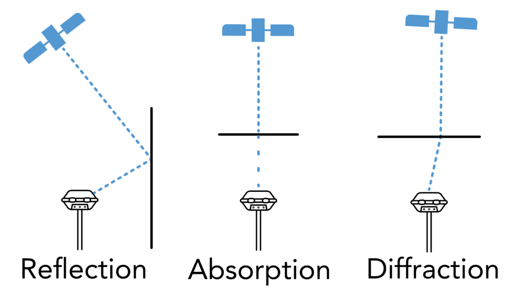
The effect on a signal when striking a surface can vary significantly based on the material composition, the incident angle, and the power of the signal, contributing to gps multipath issues.
Certain environments are more susceptible to multipath interference, and identifying these can help in planning and executing accurate RTK surveys. Knowing your terrain before you arrive on site will better help you plan how to conduct your survey.
Buildings: Structures with metal and glass facades are particularly problematic. These large, flat surfaces act almost as mirrors, creating substantial signal reflections. On top of this, they also often obstruct significant portions of the skyline, reducing the number of usable satellites to the receiver.
Vehicles: Moving vehicles can intermittently block and reflect signals, adding dynamic multipath effects.
Urban Canyons: When tall buildings line both sides of a street or corridor, they create what’s known as an urban canyon. Signals reflect back and forth between the facing walls before reaching the receiver, and the narrow strip of visible sky can cut usable satellite geometry down dramatically. Urban canyons are widely considered one of the most difficult environments for RTK because the receiver may be tracking almost entirely reflected signals for extended stretches of a survey.
Deciduous Trees: Dense canopies and broad leaves provide extensive surface areas for signal reflection. In general, the broader the leaves on the tree, the more issues they will cause. This is down to the simple fact that the large leaves are larger in surface area.
Coniferous Trees: Needle-like leaves generally result in less severe multipath effects compared to broadleaf trees. However, due to their large size pine and spruce trees can still cause significant issues.For trees, a good rule of thumb is that the darker the shade under the tree, the more difficult the conditions will be for the receiver.
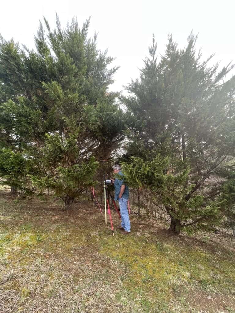
In the real world, survey markers are rarely in a convenient location, but rather under trees, near buildings or any location that will make life more difficult.
Steep slopes, rock faces, and canyon walls behave much like an urban canyon does, reflecting signals and blocking large portions of the sky. Elevation changes also mean satellites near the horizon are frequently obstructed entirely, which reduces satellite geometry and worsens PDOP even before multipath is factored in. Rock and mineral-rich surfaces can be highly reflective, compounding the problem in mountainous survey work.
Active construction sites combine several multipath sources at once: steel framing, scaffolding, temporary metal fencing, parked equipment, and partially completed structures all reflect signals unpredictably. Because the site layout changes daily as work progresses, multipath conditions at a construction site can shift significantly from one visit to the next, making it important to reassess conditions each time a survey is performed.
Open-pit mines present a unique multipath challenge. High walls and benches surrounding the pit can create a bowl-shaped obstruction similar to a canyon, limiting sky visibility for equipment and survey crews working at lower elevations. Metal haul trucks, conveyor infrastructure, and processing equipment add further reflective surfaces. Underground mining operations go a step further, typically losing GNSS signal altogether and requiring alternative positioning methods.
Marine Environments: Open water is generally favorable for GNSS reception thanks to a clear, unobstructed sky view, but multipath still shows up near docks, seawalls, bridges, moored vessels, and other marine structures. The vessel itself can also be a source of multipath, with metal railings, superstructure, and antennas mounted too close to reflective surfaces onboard. Wave action adds a further complication by causing the reflecting water surface to constantly shift, which produces a more variable multipath signature than a calm lake or river.
Lakes and Rivers: Smooth water surfaces create strong reflections, which can be problematic near shorelines. Although not as present in Southern climates, ice will also cause significant multi-path issues. When I first started at Bench-Mark way back in 2017, David and I had been testing some equipment in one of the open areas by our office, which happened to be part of a frozen river. On the river, we saw a significant increase in the signs of multipath and gave us quite a bit of grief when trying to finish our test. The latest receivers have technology to help mitigate this, but it took us a minute at the time to figure out what was happening.
Understanding the factors behind multipath is a purely academic exercise, if you cannot also identify when the receiver is telling you it is encountering multipath. Recognizing the signs of multipath interference are relatively easy and is crucial for surveyors to get the most out of their RTK equipment.
High PDOP (Position Dilution of Precision) is an indication of poor satellite geometry, which is often caused by multipath. Without diving into the math, and giving a very simplified explanation, the more clustered satellites are together the higher the PDOP value. A PDOP value above 4 suggests significant positional error. If you want to get into the weeds on PDOP, here is a great article from the University of New Brunswick: Dilution of Precision (Langley 1999).
Extended Fix Time: Longer than usual time to achieve a fixed solution can be a sign of multipath interference. It indicates that the receiver is struggling to resolve ambiguities due to signal reflections. In some tougher scenarios it can take upwards of five minutes or more to resolve a fixed solution. Check out the below video to see an example.

Float Solution: A float solution indicates that the receiver has not fully resolved the ambiguities, leading to less precise positioning. Persistent float solutions in areas with a large number of usable satellites can suggest multipath issues.
Fixed Solution: Achieving a fixed solution, where ambiguities are resolved, indicates higher precision. Difficulty in maintaining a fixed solution in certain areas may point to multipath interference.
GNSS receivers use a variety of different methods to deal with multipath and these methods are not necessarily the same across makes, models and RTK generations. How these signals are handled and filtered is down to the RTK engine onboard the receiver. Take a look at two 7th generation receivers, the Hemisphere S631 and the Leica GS18. Although both receivers are able to receive the same signals, they perform completely differently under canopy.

Advanced signal processing techniques play a crucial role in mitigating the effects of multipath on GNSS signals. These techniques leverage sophisticated algorithms and models to enhance the accuracy of timing and positional data by distinguishing between Line-of-Sight (LOS) and Non-Line-of-Sight (NLOS) signals. Here’s how advanced signal processing works:
Multipath Delay Lock Loops (MPDLL): These loops are designed to detect and compensate for multipath errors by analyzing the timing of incoming signals. MPDLLs use correlation techniques to identify and separate reflected signals from direct signals.
Phase Measurement Processing: By analyzing the phase of the carrier signal, advanced algorithms can detect phase shifts caused by multipath reflections. This helps in identifying and correcting positional errors.
Kalman Filtering: Kalman filters predict the state of the receiver’s position by combining multiple measurements over time. They are adaptive and can dynamically adjust to varying conditions, making them effective in mitigating multipath by filtering out NLOS signals.
Wavelet Transforms: Wavelet transforms decompose the signal into different frequency components, allowing the detection and suppression of multipath effects based on their unique frequency signatures.
Multipath Estimation Delay Lock Loop (MEDLL): MEDLL estimates the delay introduced by multipath and corrects the timing of the signal accordingly. This technique significantly improves the accuracy of GNSS measurements in multipath-prone environments.
Carrier-Smoothing Techniques: These techniques average out short-term fluctuations in the carrier phase caused by multipath, resulting in a smoother and more accurate positional estimate.
On top of this, the various different constellations in the sky also lend a hand. At the beginning of GNSS, there was a single frequency; L1. This frequency did not perform well under canopy but with the continuing introduction of more and more signals, like L2, L5 and more, receivers are able to perform much better under canopy. By analyzing signals on multiple frequencies, receivers can better detect and discard multipath errors.
While no RTK system can eliminate multipath entirely, surveyors can significantly reduce its impact through careful planning and good field practice. The following best practices apply across nearly every survey environment:
How multipath shows up and how surveyors respond to it varies considerably depending on the type of survey being performed. Here’s how it plays out across common surveying scenarios:
Use this checklist in the field to quickly assess and reduce multipath risk:
Multipath is a significant source of error in RTK surveying, but understanding its causes and mitigation strategies can greatly improve measurement accuracy. Surveyors must be vigilant in identifying environments prone to multipath and employ both satellite and receiver-based techniques to mitigate its effects. Advanced technology and best practices in GNSS data collection can ensure reliable and precise survey results.
Multipath refers to the phenomenon where GNSS signals reflect off surfaces before reaching the receiver, resulting in Non-Line-of-Sight (NLOS) signals. It is crucial in RTK surveying because these reflections cause delays and positional inaccuracies, making it one of the largest sources of error in GNSS data. Proper understanding and mitigation of multipath can distinguish between a successful survey and a failure.
Certain environments are more prone to multipath interference, including:
– Urban Areas: Buildings with metal and glass facades, vehicles, and other large structures that reflect signals.
– Vegetated Areas: Dense canopies of deciduous trees and large coniferous trees.
– Water Bodies: Smooth surfaces of lakes and rivers, especially near shorelines.
There are several indicators that multipath is affecting your survey:
– High PDOP (Position Dilution of Precision): Indicates poor satellite geometry, often caused by multipath. A PDOP value above 4 suggests significant positional error.
– Extended Fix Time: Longer than usual time to achieve a fixed solution, indicating the receiver is struggling with signal reflections.
– Float Solutions: Persistent float solutions in areas with many usable satellites suggest multipath issues.
– Difficulty Maintaining Fixed Solutions: Difficulty maintaining a fixed solution in certain areas may point to multipath interference.
GNSS receivers use various methods to handle multipath, including:
– Advanced Signal Processing: Techniques such as Multipath Delay Lock Loops (MPDLL), phase measurement processing, and multipath estimation and correction.
– Adaptive Filtering: Methods like Kalman filtering and wavelet transforms to filter out NLOS signals.
– Real-Time Corrections: Network RTK and Virtual Reference Stations (VRS) provide real-time corrections to mitigate multipath errors.
– Multi-Frequency Reception: Analyzing signals on multiple frequencies (e.g., L1, L2, L5) to detect and discard multipath errors.
Surveyors can adopt several strategies to minimize multipath errors:
– Use High-Quality Equipment: High-quality receivers and antennas with advanced filtering techniques.
– Plan Surveys Carefully: Identify and avoid environments prone to multipath, such as urban areas with reflective surfaces or dense vegetated regions.
– Monitor PDOP Values and Fix Times: Regularly check PDOP values and fix times to identify potential multipath issues and adjust survey methods accordingly.
Bench Mark Equipment & Supplies is your team to trust with all your surveying equipment. We have been providing high-quality surveying equipment to land surveyors, engineers, construction, airborne and resource professionals since 2002. This helps establish ourselves as the go-to team in Calgary, Canada, and the USA. Plus, we provide a wide selection of equipment, including global navigation satellite systems, RTK GPS equipment, GNSS receivers, and more. We strive to provide the highest level of customer care and service for everyone. To speak to one of our team today, call us at +1 (888) 286-3204 or email us at [email protected]