

Today, we’re diving into the basics of grid vs. ground coordinates in surveying. If you’re out in the field with RTK GPS, you need to understand the difference, as using the wrong set of coordinates can give you measurements that are off by more than a foot! This can be the difference between placing a foundation in the wrong place and finishing a project successfully.
In this guide, we’re going to break down:
The Difference Between Grid and Ground Coordinates
Why Do We Need Both Grid and Ground Coordinates?
How to Convert Between Grid and Ground Coordinates
RTK GPS and Grid vs. Ground Coordinates
Common Mistakes (And How to Avoid Them)
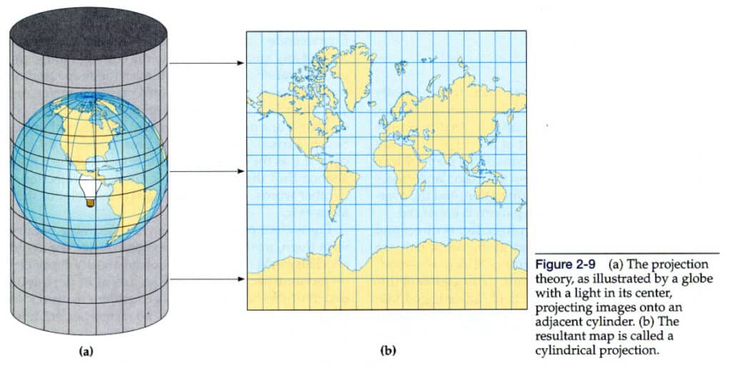
Grid coordinates are your positions on a map projection. Think of it like this—imagine you take a paper map and wrap it around a globe. Now, shine a light through the globe, and the shapes and positions get projected onto that paper. That’s basically what’s happening when we work with grid coordinates. They’re not real-world distances; they’re adjusted to fit a mapping system like UTM or state plane coordinates.
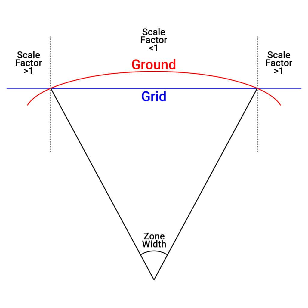
The reason surveyors use grid coordinates is because they make math and measurements easier. If you want to figure out the difference between two points, working in a flat, projected space is way simpler than dealing with all the spherical trig that comes with the Earth’s actual shape. But, because this is a projection, it introduces some distortion.
A grid survey is a method of surveying where positions are recorded and plotted using a projected coordinate system, such as UTM or state plane coordinates. The survey data are adjusted for the mapping projection, which simplifies calculations of distances, angles, and areas on a flat plane. Grid surveys are widely used for GIS mapping, infrastructure planning, and large-scale engineering projects. To convert grid survey measurements to actual ground distances, scale factors must be applied.
Ground coordinates, on the other hand, are the real-world measurements that make sense to us. If you measure a meter with a tape measure, that’s a true meter. If you measure 10 feet, that’s exactly 10 feet—no distortion, no weird projection effects. This is why ground coordinates are what people on-site actually use when laying out roads, buildings, and property lines.
If you’re looking at a grid map and then measuring things in real life, you’ll notice the numbers don’t always match up. That’s because grid coordinates have to be adjusted to reflect actual ground distances. If you don’t account for that, your project could be off, and that’s a big problem when you’re trying to be precise.
So, here’s where things get interesting. The main difference between grid and ground coordinates comes down to distortion and scale factor.
1. Projection Distortion – Grid coordinates are stretched or compressed to fit a mapping projection, which means distances can be slightly off from what you’d measure in the real world.
2. Scale Factor – To go from grid coordinates to ground coordinates, you use what’s called a combined scale factor. It’s usually something like 0.99962322. Looks tiny, right? But over a long distance, even a small difference can throw you off by more than a foot.
3. Real-World Application – Engineers and designers might give you coordinates in grid format, but if you’re actually building something, you’ll need ground coordinates to match real-world distances.
4. Distance Calculation – Grid coordinates make math easier on a mapping system, but if you’re working with actual distances on the ground, you need to convert them properly in order to get the proper real-world distance.
Now you might be wondering, why don’t we just use one system for everything? Well, both grid and ground coordinates have their uses, and here’s why:
– Why We Need Grid Coordinates: Grid coordinates are essential for mapping, GIS work, and large-scale planning. Since they provide a flat, consistent coordinate system, they make calculations easier when working with maps. If we had to constantly deal with the Earth’s curvature in every measurement, it would be a nightmare. Grid coordinates allow surveyors and engineers to quickly determine distances, angles, and relationships between points in a simple way.
– Why We Need Ground Coordinates: When you’re actually building something, you need real-world measurements that match up exactly with what’s on the ground. Construction crews, road builders, and property surveyors need distances that don’t include any projection distortion. Using ground coordinates ensures that what’s measured on paper translates accurately to physical reality.
Basically, grid coordinates help with planning and calculations, while ground coordinates ensure everything lines up properly in real life. The key is knowing when to use each one and making sure you convert between them correctly when needed.
Let’s say you’re laying out a road that’s a kilometer long. If you don’t account for the difference between grid and ground, your measurements could be off by more than a foot. That’s enough to cause major problems in construction, property boundaries, and anything that requires precision.
That’s why, before you start a project, you need to ask:
– Are we working in grid or ground coordinates?
– Did the engineer give us the right system to work with?
– Are we using the correct scale factor?
Alright, so how do you actually switch between these two? It’s all about applying the right scale factor. Here’s the basic formula:
Ground Distance = Grid Distance x (1 / Scale Factor)
If you’re using surveying software like FieldGenius, you can set up a single-point scale factor and let the software handle the math. Just make sure you double-check your settings so everything matches what the engineers are using. You can check out Survey-Assistant.com to learn more about everything FieldGenius can do for you.
When you’re using RTK GPS, it’s critical to know whether your system is outputting grid or ground coordinates. Here’s why:
1. Mapping and GIS Work – Grid coordinates are great when you’re mapping large areas or working with GIS systems.
2. Construction Layouts – You want ground coordinates to match real-world measurements on the job site.
3. Property Boundaries – If you’re marking out a legal boundary, using the wrong system could lead to disputes.
4. Infrastructure Projects – Roads, pipelines, and buildings all need precise layouts, so you can’t afford errors in your coordinates.
Surveyors commonly use three methods to measure distances accurately.
Using tape measures, chains, or steel bands to measure the distance between two points physically. This method is simple but less practical over long distances.
Instruments like total stations use electromagnetic waves to calculate distances with high accuracy, suitable for medium to long-range surveys.
Using Global Navigation Satellite Systems with real-time kinematic (RTK) corrections, surveyors can measure distances accurately without physically traversing the terrain, ideal for large or inaccessible areas.
One of the biggest mistakes surveyors make is not double-checking whether they’re working in grid or ground coordinates. This can lead to:
– Buildings being laid out in the wrong place.
– Property lines being marked incorrectly.
– Construction errors that cost time and money.
Here’s how to avoid those problems:
1. Check the Project Specs – Always confirm whether your drawings are in grid or ground coordinates.
2. Verify Software Settings – Make sure your RTK GPS or surveying software is using the right system.
3. Do a Quick Distance Check – Measure a known ground distance and compare it to the grid measurement to see if they match up.
4. Document Everything – Clearly mark whether your data is in grid or ground coordinates to prevent confusion.
At the end of the day, knowing the difference between grid and ground coordinates can save you a ton of headaches. Grid coordinates make it easy to do calculations on a map, but ground coordinates are what actually matter in the real world. If you’re out surveying, always check which system you’re working in and apply the right scale factor when needed.
And if you want to see just how easy it is to set up a single-point scale factor in FieldGenius, check out our Survey-Assistant.com website for tutorials and guides.
Surveyors use grid coordinates because they make calculations easier when working with maps and GIS systems. Since they provide a flat, consistent coordinate system, they simplify distance and angle measurements without dealing with the Earth’s curvature.
Grid coordinates introduce distortion because they are based on a projected map rather than actual ground distances. If you don’t convert them properly, your measurements could be off, sometimes by more than a foot over long distances.
Use ground coordinates when laying out roads, buildings, or property lines. Since ground coordinates reflect true physical distances without distortion, they ensure accuracy when working in real-world conditions.
A scale factor is a value used to convert grid distances to ground distances. It accounts for distortions in the mapping projection and the Earth’s curvature. If you don’t apply the correct scale factor, your measurements may not align correctly on-site.
Always check whether your project is using grid or ground coordinates, verify the scale factor, and confirm your software settings. Measuring a known distance and comparing it to your calculations can help catch errors before they become costly mistakes.
The grid conversion factor, also known as the combined scale factor, is a value used to convert distances measured on a projected grid (grid coordinates) to actual ground distances. It accounts for the distortion introduced by map projections and the Earth’s curvature. For example, if your grid distance is 1,000 meters and your scale factor is 0.99962322, the ground distance would be 1,000 x (1 / 0.99962322) ≈ 1,000.38 meters.
A horizontal angle in surveying is measured between two points in the horizontal plane using instruments like a total station, theodolite, or transit. The instrument is set over a known point, and the telescope is rotated to sight the first target and then the second target. The angle between the two sight lines is recorded as the horizontal angle.
The accuracy of horizontal distance measurements depends on the equipment and method used. Using high-precision RTK GPS or total stations, horizontal distances can be measured with centimeter-level accuracy over short distances and within a few millimeters per kilometer over longer baselines. Environmental factors, instrument calibration, and signal quality can also influence measurement accuracy.
Bench Mark Equipment & Supplies is your team to trust with all your surveying equipment. We have been providing high-quality surveying equipment to land surveyors, engineers, construction, airborne and resource professionals since 2002. This helps establish ourselves as the go-to team in Calgary, Canada, and the USA. Plus, we provide a wide selection of equipment, including global navigation satellite systems, RTK GPS equipment, GNSS receivers, and more. We strive to provide the highest level of customer care and service for everyone. To speak to one of our team today, call us at +1 (888) 286-3204 or email us at [email protected]
